-40%
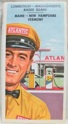
ATLANTIC SERVICE STATION NEW ENGLAND STATES HIGHWAY ROAD MAP 1960 VINTAGE TRAVEL
$ 2.89
- Description
- Size Guide
Description
Vintage Atlantic service station highway road map of the New England States circa 1960. Includes: Connecticut, Rhode Island, Massachusetts, Vermont, New Hampshire and Maine . Measures 23 X 35 1/2 inches in size when fully opened (59 X 90cm). Map is an authentic original in very good condition as shown in photos.ATLANTIC SERVICE STATION NEW ENGLAND STATES HIGHWAY ROAD MAP 1960 VINTAGE TRAVEL
ATLANTIC SERVICE STATION NEW ENGLAND STATES HIGHWAY ROAD MAP 1960 VINTAGE TRAVEL
Click images to enlarge
Description
Vintage Atlantic service station highway road map of the New England States circa 1960. Includes: Connecticut, Rhode Island, Massachusetts, Vermont, New Hampshire and Maine . Measures 23 X 35 1/2 inches in size when fully opened (59 X 90cm). Map is an authentic original in very good condition as shown in photos.
Pictures sell!
Auctiva offers Free Image Hosting and Editing.
300+
Listing Templates!
Auctiva gets you noticed!
The complete eBay Selling Solution.
Every buyer gets a MyStoreRewards invitation for cash back
Track Page Views With
Auctiva's FREE Counter


